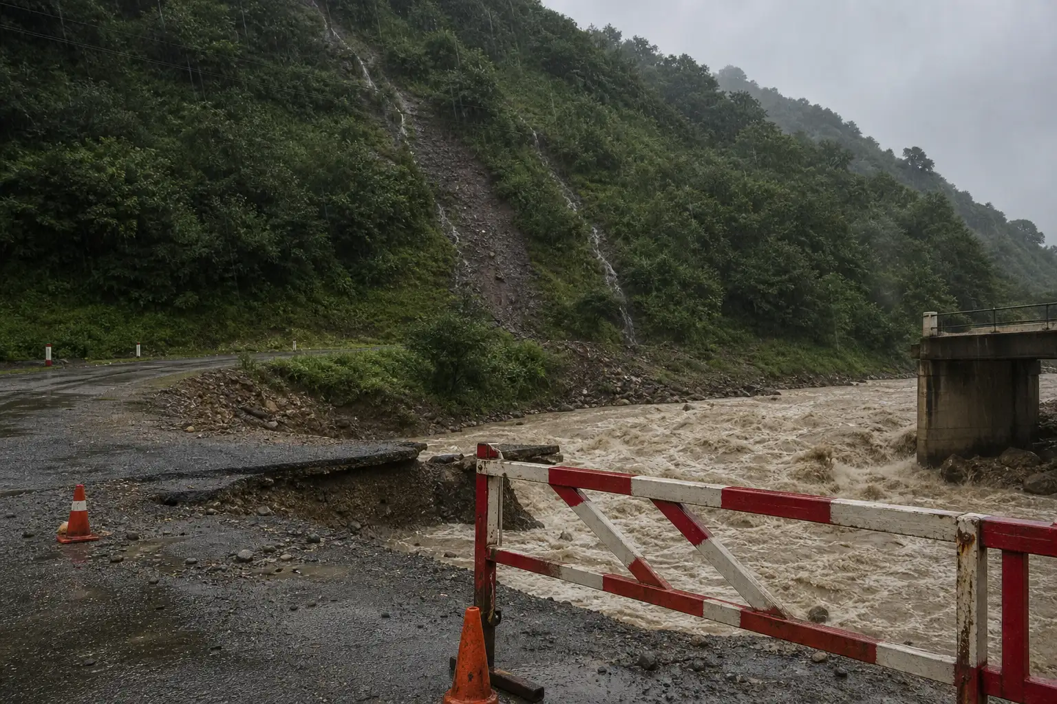
A river jumped its banks near Georgia’s Sakdri Bridge on Sunday, sending floodwater across a mountain highway in the western Imereti region. Officials shut the road at kilometer 98 of the Kutaisi-Tskaltubo-Tsageri-Lentekhi highway, warning that saturated slopes could give way without notice.
It is the same rural corridor, and the same broader mountain region, that produced Georgia’s deadliest landslide of the century less than three years ago. The Roads Department of Georgia’s Ministry of Regional Development and Infrastructure called Sunday’s closure a precaution. Heavy rain in this exact district has preceded worse before.
A River Takes Out the Sakdri Bridge Crossing
The flooding hit the Kutaisi (Tskaltubo bypass)-Tskaltubo-Tsageri-Lentekhi-Lasdili state highway, the paved link running from Imereti’s regional capital up into the mountains of Racha-Lechkhumi and Kvemo Svaneti. Near the Sakdri Bridge, a swollen river spilled over its banks and swept across the roadway itself.
The Roads Department said the flooding had severely compromised the road infrastructure at the 98th kilometer mark and banned all vehicle movement along the affected stretch. Traffic will stay off the road until the water recedes and engineers can confirm the surface and roadbed are still sound.
Officials tied the ban to a second, quieter danger. Days of rain have saturated the hillsides above the highway, and Georgian authorities said that raises the odds of a sudden landslide on top of the flooding already reported.
The Lentekhi Corridor Has Flooded Before
This is not new ground for a washout. A wave of storms in June 2023 tore across six of Georgia’s regions at once, and relief agencies later found the damage was not evenly spread. Out of fifteen affected municipalities, aid workers flagged only two as recurring flood hotspots hit multiple times that season: Gurjaani in the east, and Lentekhi, the same district this highway feeds into.
Eight months later, a separate string of storms battered western Georgia again. In February 2024, a landslide struck the village of Nergeeti in Baghdati, an Imereti municipality neighboring Tskaltubo, and cost a life, part of a wider event that the Red Cross tallied at more than 550 affected families in Georgia’s west that week alone.
The pattern shows up in the numbers, not just the anecdotes. Below is how the same stretch of western Georgia has fared across three recent events, plus Sunday’s closure.
| Date | Location | Event | Recorded Impact |
|---|---|---|---|
| June 15 to 16, 2023 | Lentekhi and Gurjaani municipalities | Flash floods, hail, mudflows | Roads, bridges and power lines damaged; flagged as a recurring hotspot |
| August 3, 2023 | Shovi, Oni Municipality (Racha-Lechkhumi and Kvemo Svaneti) | Glacier-fed landslide | More than 30 people killed, resort infrastructure destroyed |
| February 6 to 7, 2024 | Nergeeti, Baghdati Municipality (Imereti) | Nighttime landslide | Loss of life; part of a regional event affecting 550 plus families |
| July 19, 2026 | Sakdri Bridge, km 98 of the Lentekhi highway | River overflow, flash flooding | Highway closed indefinitely, landslide risk rated high |
Shovi’s Landslide Still Looms Over Racha-Lechkhumi
Lentekhi sits inside Racha-Lechkhumi and Kvemo Svaneti, the same administrative region as Oni, the mountain district where a resort town called Shovi was buried by a landslide on August 3, 2023. It remains the deadliest natural disaster Georgia has recorded this century.
The slide tore through the Sunset Shovi hotel and nearby cottages during peak summer season, killing more than 30 people. Rescue crews evacuated over 200 people and, according to the death toll reported as search efforts continued in the days after, kept finding bodies for nearly a week.
Geologists pinned the cause on the mountains themselves warming up. Merab Gaprindashvili, a geologist with Georgia’s National Environmental Agency, told reporters at the time that “there are two glaciers in the headwaters of the river, which are intensively melting.”
Did Georgia Have Time to Warn Shovi?
Short answer: sources disagree. Georgia’s own National Environment Agency concluded in its 2024 investigation that no realistic monitoring setup could have caught Shovi’s landslide fast enough to matter. A Swiss engineering review and an Ilia State University institute reached a different conclusion, arguing a working system could have bought people several critical minutes.
The gap between those two findings is where the argument over Georgia’s disaster response still lives.
- Georgia’s National Environment Agency – its official report argued an early warning system would have been ineffective given the slide’s speed and terrain
- GEOTEST AG, a Swiss engineering firm – its review found that a functioning system could have given residents 8 to 10 minutes to reach higher ground
- The Institute of Earth Sciences and National Seismic Monitoring Center at Ilia State University – marking the disaster’s first anniversary, it concluded an early warning system could have averted the Shovi disaster entirely
Environmentalists have been blunter still about what the state has and has not built since.
Georgia does not have an adaptive action plan.
Nino Chkhobadze, an environmentalist and chairwoman of the Green Movement of Georgia, said that a year after Shovi, pointing to gaps in how the country plans for repeat disasters rather than just reacting to each one.
Peak Season Traffic Meets a Closed Road
The timing compounds the problem. Late June through August is the busiest stretch of the year for Racha-Lechkhumi and Kvemo Svaneti, when Georgian families head into the mountains to escape lowland heat and the region’s guesthouses fill up.
The closed highway is the only paved route connecting Imereti and Kutaisi to that entire mountain region. Several things funnel through this one road and its Sakdri Bridge crossing during exactly this window:
- Mountain villages in Lentekhi and Tsageri districts that depend on the highway for supplies and emergency access
- Wine tourism traffic heading to Racha’s Khvanchkara vineyards, reachable only through Lechkhumi
- Visitors to the Shovi and Utsera spa resorts, still drawing summer crowds since the 2023 disaster
- Travelers using the unpaved Zagari Pass, which links Lentekhi to Svaneti’s Ushguli and only opens between June and October
A prolonged closure does not just delay a drive. It cuts off the only paved approach to a district that already goes quiet and hard to reach the rest of the year.
Georgia’s Race to Outrun the Rain
Georgia has not ignored the warning signs since Shovi. A seven year, 74 million dollar resilience program backed by the Green Climate Fund, Sweden and Switzerland has been rolling out hazard maps and monitoring gear across the country’s eleven major river basins.
The stakes behind that spending are large. Over a 21 year stretch, hydrometeorological disasters cost Georgia roughly 2.8 billion lari (about 1.2 billion dollars) and 152 lives, and floods, landslides and mudflows alone accounted for 60 percent of the damage and 67 percent of the deaths in that period.
New hardware is going in. Georgia has installed 79 new hydrometeorological monitoring stations nationwide, with 77 more currently being deployed, alongside geological sensors in known landslide zones.
Just over a week before Sunday’s closure, Georgia’s National Environment Agency met with government partners to roll out a new information technology system meant to speed up how quickly hazard data reaches the right agencies. Agency head Elene Ghubianuri led the July 10 session alongside deputies and donor representatives.
What that system still cannot do is watch the glaciers and permafrost that triggered Shovi in the first place; regional monitoring of those specific triggers remains thin. For now, the fix at kilometer 98 is simpler and older: wait for the water to drop, then send engineers to check what is left of the road.
Frequently Asked Questions
Why does Imereti flood so often in Georgia?
Part of it is geography. A hazard assessment for Tskaltubo, the Imereti town nearest this closure, classifies river flood risk there as medium, meaning better than a 20 percent chance of a damaging, life threatening flood within any given 10 year window. Georgia as a whole has more than 20,000 rivers cutting through steep terrain, which multiplies the exposure nationwide.
What is the Zagari Pass, and does this closure block it?
The Zagari Pass is an unpaved mountain road linking Lentekhi, in Lechkhumi, with Ushguli in Svaneti. It requires a four wheel drive vehicle and normally operates only from June through October. Because the paved Kutaisi to Lentekhi highway is the main approach to that pass, this week’s closure effectively strands travelers trying to reach it from the Imereti side.
How many Georgians live in flood or landslide risk zones?
Around 40 percent of the population lives in areas vulnerable to floods, landslides, droughts and avalanches, according to a 2025 update from the United Nations on Georgia’s climate resilience work. That vulnerability is concentrated in exactly the kind of steep, river cut terrain the Lentekhi highway passes through.
Is it safe to visit Georgia’s mountain regions this summer?
Racha-Lechkhumi and Kvemo Svaneti remain open and popular for the 2026 peak season, but road conditions in the mountains change fast after heavy rain. As of this reporting, the Lentekhi highway stays closed at kilometer 98, and travelers heading into the region should check current road status before setting out rather than assume a route is passable.