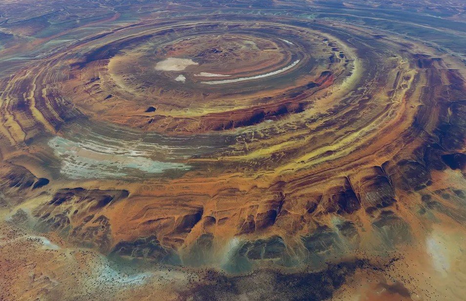
An astronaut aboard the International Space Station captured a striking view over Libya, showing massive circular rock formations rising out of the Sahara desert—geological rings that once fooled researchers into thinking a meteorite had struck the region millions of years ago.
A Strange Pattern in the Sand That Once Sparked Wild Theories
The photograph, taken on September 13 by NASA’s Expedition 73 crew, shows the Jabal Arkanu massif throwing long shadows across pale desert sand.
These shadows outline rings sprawling more than 24 kilometers wide.
For decades, many people believed these formations were impact craters created by space rocks slamming into Earth.
The symmetry fed that assumption.
Scientists later uncovered a different truth.
It wasn’t cosmic debris—it was Earth reshaping itself from the inside.
Jabal Arkanu, sitting in southeastern Libya near the Egyptian border, is an enormous alkaline igneous ring complex.
Its rocks date back roughly 50 million years.
That single line feels necessary: Earth’s own magma carved these shapes, not meteorites.
Nearby, Jabal al Awaynat—20 kilometers southeast—shows a similar structure, confirming the region’s long history of deep volcanic activity beneath the surface.
How Ancient Magma Created Those Overlapping Rings
According to NASA, the circular layers formed as repeated magma intrusions pushed upward into older rock.
Each event created a new ring.
Over time, these intrusions overlapped like ripples from stones tossed into a pond, forming a southwest-aligned stack of geological arcs.
It’s a simple metaphor, but it fits.
Fieldwork eventually debunked high-profile impact theories.
Researchers found no shock features—no melted glass, no pressure signatures, none of the telltale signs of a meteor blast.
Instead, they found minerals such as aegirine, eudialyte and zircon, all consistent with igneous processes deep within Earth’s crust.
It was a confirmation that the so-called “Arkenu structures” were purely terrestrial.
Here’s a bullet-point takeaway that sits at the heart of this discovery:
-
The rings are the result of multiple magma intrusions, not collisions from space.
A quick one-line pause: mysteries in deserts tend to invite grand explanations, but this one stayed close to geology.
These findings repositioned Jabal Arkanu as a valuable natural laboratory for studying intrusive rock systems in extreme environments.
Shadows, Sand, and the Harsh Reality of Water in the Sahara
The ISS photo was taken using an 800mm lens, capturing ridge lines that rise nearly 1,400 meters above the desert floor.
Some cliffs drop sharply, casting shadows that stretch across the plains.
The lower slopes spread boulder outwash fans that slide into long, ribbon-like dunes shaped by relentless Saharan winds.
The contrast looks dramatic from orbit—light sands against dark stone arcs.
Two dry wadis slice through the massif.
They hint at a climate that once may have been wetter.
But rainfall here is shockingly low: only 1 to 5 millimeters a year in most places.
Higher elevations may receive 5 to 10 millimeters due to orographic lift, but that’s still barely anything.
A small valley oasis provides seasonal grazing land.
Local Bedouin communities rely on it during infrequent green periods, and access is sometimes restricted while herders use it.
This one-sentence paragraph keeps it honest: life in the area is sparse, fragile, and deeply tied to rare water pockets.
From space, the contrast between life and raw rock becomes even clearer.
It’s one reason astronauts often describe the Sahara as both timeless and strangely delicate.
What Researchers Learned From Studying the Rings Up Close
While the photo shot into global headlines, the groundwork began decades earlier.
Early expeditions hoped to study impact structures similar to those found elsewhere in Africa.
They didn’t find what they expected.
Instead of shocked quartz or melt sheets, they discovered intact igneous layers and mineral zones that pointed to slow, molten intrusions.
Geologists pieced together the sequence: magma rose in pulses, cooled, rose again, then fractured surrounding rock to create fresh arcs.
The pattern repeated enough times to produce the rings visible from orbit.
Below is a simple table summarizing the composition and key traits of the massif:
| Feature | Details |
|---|---|
| Geological Type | Alkaline igneous ring complex |
| Dominant Rocks | Basalt, granite, syenite, trachyte, phonolite |
| Age | ~50 million years |
| Height | Up to 1,400 meters |
| Width | ~24 kilometers |
| Formation Cause | Repeated magma intrusions |
NASA confirmed these features in its release, emphasizing how orbital photography helps spotlight formations that remain otherwise unreachable to most scientists.
Another single-line paragraph flows here: sometimes it takes an astronaut’s camera to remind us how much Earth hides in remote corners.
Researchers say the Arkanu complex and its neighbors provide rare windows into deep crust processes exposed by erosion over millions of years.
Few places on Earth reveal ring intrusions so clearly.
Why This Image Caught Global Attention So Quickly
Photos of Earth from space always stir curiosity.
But perfectly formed circles carved into a desert? That sparks imagination.
People immediately speculated about ancient impacts, lost civilizations, even supernatural origins.
That kind of thing happens online.
NASA’s confirmation cooled those theories, but the image still captivated scientists and casual observers.
It shows geology exposed like a cross-section drawing.
The Expedition 73 crew snapped dozens of images of North Africa on that pass, but this one stood out—its mix of light, shadow, and geometry made it feel almost unreal.
The desert has a way of making rock look otherworldly.
A one-sentence pause: sometimes beauty alone is enough to draw attention.
As researchers continue studying the region, they say the massif remains remote, difficult to reach, and even harder to explore.
Political conditions and harsh climate reduce on-site fieldwork opportunities.
Still, satellite and astronaut photography offer fresh chances to analyze the terrain without ever touching foot on the ground.
And that’s how these ancient rings ended up spotlighted by a camera hurtling hundreds of kilometers above Earth.