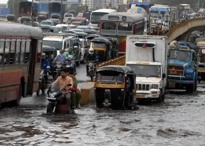
A fresh round of monsoon fury is set to lash large swathes of India as the India Meteorological Department (IMD) issues an Orange Alert for July 22. The warning, signalling potential disruption and localized hazards, covers critical stretches from the Himalayan foothills to coastal belts, including Uttarakhand, Maharashtra, Goa, Telangana, and Jammu & Kashmir.
Meanwhile, Delhi is bracing for wet spells and subdued temperatures, with cloudy skies and thunderstorms likely through July 24. The IMD’s advisory urges residents to stay cautious amid fluctuating temperatures, sharp bursts of rain, and lightning activity.
Intensity Mounts Across the Western Ghats and Himalayas
From Raigad and Ratnagiri in Maharashtra to Rudraprayag and Dehradun in Uttarakhand, the meteorological agency’s Orange Alert points to the risk of flash floods, waterlogging, and landslides in hilly regions and coastal lowlands alike.
In the Konkan belt, IMD forecasters predict very heavy rainfall through the week, particularly affecting Satara, Kolhapur, Sindhudurg, and the coastal zones of Goa. South Goa and North Goa districts are specifically flagged for high-impact rainfall, potentially disrupting local transport and daily life.
On the northern edge, Jammu and Kashmir districts such as Poonch, Reasi, Kathua, and Ramban face similar forecasts, with heightened vigilance advised for vulnerable slopes and water channels.
Three-Day Rain Radar: Where It’s Falling, How Hard
Here’s a breakdown of the Orange Alerts issued over the next three days across India:
| Date | States Affected | Key Districts Under Alert |
|---|---|---|
| 22 July | J&K, Uttarakhand, Maharashtra, Goa, Telangana | Poonch, Dehradun, Raigad, South Goa, Kamareddy, among others |
| 23 July | J&K, Odisha, Telangana, Maharashtra | Rajouri, Nayagarh, Bijapur, Pune |
| 24 July | J&K, Bihar, Maharashtra, MP, Chhattisgarh | Udhampur, Araria, Gadchiroli, Balaghat, Dantewada, South 24 Parganas |
Delhi Weather: Wet Spells and Below-Normal Temperatures
The National Capital Region won’t be spared either. While not under the Orange Alert, Delhi’s weather will remain unsettled over the next 72 hours:
-
22 July: Cloudy sky, light to moderate rain, thunder and lightning. Max: 31–33°C | Min: 24–26°C
-
23 July: Very light to light rain expected. Max: 31–33°C | Min: 23–25°C
-
24 July: Partly cloudy skies with light rain. Max: 34–36°C | Min: 24–26°C
Minimum temperatures are expected to hover 1–4°C below normal through much of the period.
South India: Heavy Rainfall Marches In
The southern peninsula, particularly Telangana, Kerala, Mahe, and South Interior Karnataka, is also under the radar for intense rainfall activity from July 22 to 27. The IMD expects:
-
Strong surface winds (40–50 kmph) in many parts of South India
-
Heavy to very heavy rainfall in Telangana on 22–23 July
-
Widespread rain across Coastal Andhra Pradesh, Rayalaseema, and Tamil Nadu over the next 5–7 days
Western Karnataka and Lakshadweep may also see persistent wet weather with lightning risk.
Central and Eastern India Also in Line of Fire
Rain activity over Chhattisgarh, Madhya Pradesh, Odisha, and Bihar is expected to intensify between 23 and 27 July, according to IMD’s extended forecast. Among the hardest-hit may be:
-
West Madhya Pradesh on 26–27 July
-
East Madhya Pradesh and Vidarbha from 25–27 July
-
Jharkhand and Gangetic West Bengal during the latter half of the week
The IMD has also raised the possibility of gusty winds (30–40 kmph) along with heavy rainfall in the central belt.
Northeast India: Wet Week Ahead
In the northeast, Arunachal Pradesh, Assam, Meghalaya, and Nagaland are expected to witness moderate to heavy rainfall from 22 to 27 July. Thunderstorms and lightning are expected across the region throughout the week, with potential travel disruptions.
Regions Under Watch: July 22 Orange Alert Snapshot
-
Jammu & Kashmir: Poonch, Kathua, Kishtwar, Doda, Samba
-
Uttarakhand: Dehradun, Uttarkashi, Rudraprayag
-
Maharashtra: Raigad, Satara, Kolhapur, Sindhudurg
-
Goa: North Goa, South Goa
-
Telangana: Adilabad, Nizamabad, Karimnagar, Kamareddy
Residents in these areas are advised to monitor local advisories and avoid travel in high-risk zones.
Bottom Line
While the monsoon brings much-needed rainfall to recharge reservoirs and support agriculture, the spike in intensity and uneven distribution this year has raised concerns about flooding, landslides, and infrastructure strain in multiple states. The IMD’s Orange Alerts point to a critical phase in the 2025 monsoon season — one where preparation could make all the difference.