State braces for more downpours and possible flash flooding through Tuesday evening
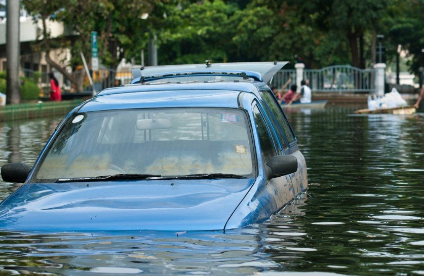
A rare stretch of cooler-than-usual temperatures and soaking rains has turned the start of August into a soggy headache for much of Georgia — and the skies aren’t done yet. The flood watch blanketing metro Atlanta and the western half of the state has now been extended through Tuesday evening, with forecasters warning of more flooding as rain continues to pound the region.
Some areas could see up to 10 inches of rainfall between Sunday and Tuesday night, turning streams into rivers and parking lots into puddles. It’s been a slow-moving mess — and it’s not going anywhere fast.
Dreary first day of school meets messy streets
Kids heading back to school Monday were greeted by umbrellas, puddles, and bumper-to-bumper traffic as temperatures stalled around 70°F — unseasonably cool for August.
For Atlanta-area school districts, it was a damp and dreary kickoff.
Bus routes were delayed. Parents faced flooded intersections. And for many, just getting to class felt like a trek through the tropics.
“This has to be the weirdest start to the school year I’ve seen,” said Marsha Tilson, a Fulton County parent. “It felt more like February than August.”
One sentence? Wet backpacks. Slippery hallways. A truly Georgia-style welcome back.
Where it’s falling — and how much is still coming
Rain has been soaking Georgia since the weekend, with some counties already clocking 1 to 3 inches between Saturday and Monday morning.
But it’s not over.
The National Weather Service says we could see:
-
Another 1 to 3 inches Monday
-
2 to 4 inches more Tuesday
-
Up to 6 additional inches in localized pockets
Add that up, and you’ve got some serious flood potential.
Urban areas with poor drainage are especially at risk. And so are low-lying spots near creeks, rivers, and streams.
Flash flood warnings hit parts of southwest Georgia
On Monday night, flash flood warnings lit up phones across parts of southwest Georgia, including:
-
Clay County
-
Dougherty County
-
Lee County
-
Randolph County
-
Terrell County
These warnings were tied to slow-moving, rain-heavy thunderstorms. And while the storms eventually moved out, the water stuck around a bit longer.
Even in areas not under warning, runoff and standing water created hazards for both drivers and homeowners.
One sentence here: Watch those backroads — and don’t test that puddle.
Covington flood evacuees return home after Sunday scare
In Covington, about 30 residents were briefly evacuated Sunday afternoon from the Nixon Circle neighborhood after water began rising rapidly.
City officials said water levels receded within a few hours and no one was injured. But it was a wake-up call for many who had never dealt with flooding in that area before.
“I’ve lived here 18 years and never seen it come up like that,” said Ronald Banks, a resident of Nixon Circle. “I barely had time to grab my dog.”
His neighbor had water climb up the steps but stop just short of the front door.
It was that close.
Why is this happening now?
Georgia doesn’t usually get extended cool, rainy spells in August. But this pattern is a bit of a meteorological curveball.
Here’s what’s going on:
-
A stalled front over the Southeast has locked moisture in place
-
High pressure systems out west are preventing typical wind flow
-
Gulf moisture is feeding into the system, keeping rains steady
It’s not your everyday summer storm setup. And it’s why temperatures have dipped and skies have barely cracked open for sunshine in days.
Forecasters say this pattern could linger into midweek before slowly shifting east.
So what should you do now?
If you live in a flood-prone area, it’s time to stay alert.
The National Weather Service continues to stress the risk of excessive runoff that could trigger sudden flooding — especially near creeks and in neighborhoods with poor drainage.
Here’s a quick checklist if rain continues where you are:
-
Don’t drive through flooded roads, even if they look shallow
-
Charge your phone and devices, in case of power outages
-
Check on elderly neighbors who may not be monitoring alerts
-
Secure loose outdoor items, as storms can kick up wind bursts
-
Keep sandbags ready if your property has flooded before
The flood watch remains in effect through 8 p.m. Tuesday — though the situation could change rapidly with any new thunderstorm development.