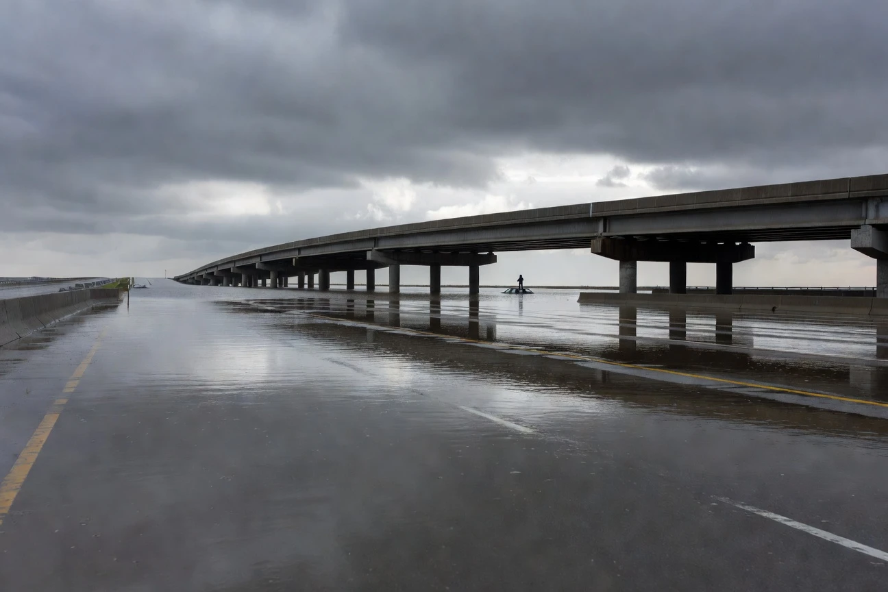
Floodwater topped the asphalt on Interstate 75/85 through downtown Atlanta for 90 minutes on Wednesday afternoon, trapping at least four vehicles near Baker Street on the Downtown Connector, submerging one sedan to window level within two minutes of the storm’s peak intensity and forcing a driver onto her car’s roof to wait for rescue. No injuries were reported, and northbound lanes reopened just before 6:30 p.m. But the rain that shut the highway down came in at 2.5 to 3 inches over roughly two hours, not a once-in-a-generation event; just a hard summer thunderstorm that a functional drainage system should have processed.
The reason it did not is what state and city crews were scrambling to fix before dawn Thursday: Atlanta’s storm drains along the corridor had spent weeks packed with leaves, litter, and organic debris after a prolonged dry spell. When the rain finally arrived in force, every exit below the pavement was already blocked.
Ninety Minutes on the Connector
The timeline moved faster than most commuters realized until they were already in it. Georgia Department of Transportation (GDOT, the state agency responsible for I-75/I-85 maintenance) cameras along the corridor picked up standing water forming near the Baker Street overpass by 5:32 p.m. Within minutes, a driver in a white sedan was visible on the car’s roof, surrounded by fast-rising water on both the northbound and southbound lanes.
Five moments defined the closure from opening surge to partial recovery:
- 5:16 p.m.: Radar confirmed up to 1.5 inches of rainfall already across warned areas as two slow-moving storm cells sat nearly stationary over downtown and Midtown, stalling rather than tracking north as typical convective systems do in summer.
- 5:32 p.m.: GDOT cameras captured vehicles trapped at Baker Street, one driver on a car roof. Water reached window depth in a two-minute window, per emergency officials reviewing the footage.
- 5:52 p.m.: The National Weather Service Atlanta forecast office (NWS, the federal weather forecasting agency) issued a formal Flash Flood Warning covering Atlanta, Midtown, and Druid Hills, with the warning set to run until 11:15 p.m.
- 6:10 p.m.: Atlanta Fire Rescue Department, the city’s primary emergency response unit, arrived near West Peachtree Street NE to assess four impacted vehicles. All occupants had already self-evacuated before crews reached them, officials confirmed.
- 6:30 p.m.: Northbound lanes reopened as floodwaters receded; GDOT advised drivers to avoid the corridor because of heavy residual congestion.
The city’s Integrated Command Center tracked conditions throughout, coordinating with GDOT on traffic impacts and dispatching teams to drainage blockages and roadway hazards across the wider metro grid. “City teams are actively monitoring conditions, responding to affected areas, and coordinating across departments to address roadway hazards, drainage concerns, and any public safety needs,” the City of Atlanta said in a statement issued at 7:15 p.m.
Weeks of Dry Weather Set the Trap
Rain can only move as fast as the drain below it allows. That constraint explains most of what happened Wednesday. Atlanta had gone weeks without meaningful rainfall before May 20, and during that stretch, leaves, natural debris, and everyday garbage settled into the highway’s drainage inlets with nothing to flush them clear. The system was effectively pre-loaded before the first thunderstorm cell arrived over downtown.
The two cells that hit on Wednesday moved slowly, lingering over downtown and Midtown from roughly 3 p.m. into the early evening. They concentrated a large rainfall volume on a stretch of highway whose grates were already near capacity with compacted debris. The ground, baked dry and hard from weeks without rain, shed water rather than absorbed it. Everything ran sideways onto the asphalt instead of downward through the inlets.
Four numbers show how quickly a blocked system loses the fight:
- 2.5 to 3 inches: the rain that fell over Midtown and Downtown Atlanta between 3:30 and 5:30 p.m., per 95.5 WSB meteorologist Christina Edwards. On a clear drainage path, that volume moves through a highway system in stages over several hours.
- 1 to 2 inches per 30 minutes: the peak rainfall rate recorded by the NWS during the storm’s most intense phase, well above the burst-condition threshold that pushes most urban drain networks into overflow.
- 2 minutes: the span in which water at Baker Street rose from passable to vehicle-window depth, per GDOT footage reviewed by emergency officials.
- Weeks: the length of the preceding dry spell that let debris accumulate in drainage inlets with no flushing rain to push it through the system.
Michel de Keersmaecker, a Georgia Tech professor who cycled through the downtown grid during the storm, described the area as “just a mess” as he tried to navigate blocked and flooded streets on a bicycle. His street-level account matched what the GDOT cameras showed from above: a city grid that had no clear path for the water it was receiving.
Rain by the Numbers
Not all of metro Atlanta absorbed the same storm. The heaviest totals sat over downtown and the Midtown corridor, where the interstate runs through a lower-lying section of the urban grid with limited natural drainage slope to carry runoff away from the highway surface.
| Location | Estimated Rainfall | Window | Source |
|---|---|---|---|
| Downtown and Midtown Atlanta | 2.5 to 3 inches | 3:30 to 5:30 p.m. | WSB Meteorologist Christina Edwards |
| Ben Hill (Campbellton Road corridor) | Approx. 1.5 inches | Storm total | NWS radar estimate |
| Stonecrest Mall area | Approx. 1.5 inches | Storm total | NWS radar estimate |
| Commerce (Banks, Jackson, Madison counties) | Heavy rain, 40 mph gusts | After 6:25 p.m. | NWS storm report |
Wind pulled Gulf and Pacific moisture north into Georgia, sustaining the storm cells’ intensity longer than a typical afternoon thunderstorm. The NWS canceled the Flash Flood Warning at 8:15 p.m. after the primary system moved east, but subsequent cells tracked northeast through Banks, Jackson, and northwestern Madison counties, bringing half-inch hail threats well into the evening. By then the Downtown Connector was clear; northeast Georgia was just entering its worst hour.
A Veteran Walks Into the Water
George Brathwaite, an Army veteran who served from 2009 to 2013 including a deployment to Iraq, was not supposed to be on the Downtown Connector at 5:32 p.m. He and his wife Chyna were detouring through the area when they spotted a woman sitting on top of her white sedan as floodwaters rose steadily around it. He pulled over and got out of his vehicle.
I had no choice but to pull over.
Brathwaite waded into the rushing water and carried the woman to safety on his back. Chyna Brathwaite told reporters she would have gone in herself if her husband had not moved first. The couple, who said they have lived in Atlanta for eight years, described the event as unlike anything they had seen on the connector before. When reporters called him a hero, Brathwaite kept it short. “I ain’t do this for clout,” he said. Atlanta Fire Rescue Department confirmed no formal water rescues were ultimately needed beyond what Brathwaite had already completed before emergency crews arrived on scene.
A different kind of vehicle also ended up in the floodwaters that afternoon. A Waymo autonomous car (Waymo is an Alphabet subsidiary operating a driverless ride-hail service in Atlanta) drove into standing water on North Avenue near Piedmont Avenue before stopping in place. The vehicle was unoccupied at the time. Waymo recovered it, paused Atlanta service for the duration of the storms, and issued a statement saying the vehicle “encountered a flooded road and stopped” and had been recovered from the scene. Waymo’s full statement on the incident confirmed no passengers were involved at any point.
The Waymo situation raised a question the company left largely open. A system built around sensor precision and continuous map updating apparently had no live flood-depth data to route it away from the pooling street. Whether that reflects a software coverage gap or simply an edge case no routing algorithm fully handles at street level is something Waymo’s brief statement did not address.
Atlanta’s Stormwater Debt
How Dry Spells Turn Drains Into Traps
The mechanism behind Wednesday’s flooding predates Baker Street and outlasts Wednesday afternoon. Atlanta has replaced millions of square feet of soil and green space with pavement and rooftop over decades of dense urban development, steadily adding runoff volume to drainage pipes whose capacity has not kept pace. The highway corridor where the event unfolded sits at the center of one of the most impervious stretches of the metro, with the interstate itself acting as a low-lying collection channel once surface drainage is overwhelmed.
What made Wednesday acute was the dry-spell preloading. Drainage grates along the corridor had been operating as passive debris collectors for weeks, filling with leaf litter, food packaging, and organic matter between rainfall events. The City of Atlanta’s Stormwater Management Program is required under state and federal environmental regulations to inspect and maintain drainage infrastructure, but the Department of Watershed Management’s stormwater funding from the Municipal Option Sales Tax (MOST, a voter-approved levy providing roughly $12.5 million annually for stormwater projects) covers a defined scope of city-owned infrastructure. The drainage grates along I-75/I-85 fall primarily under GDOT’s jurisdiction rather than the city’s, a split that surfaced in Wednesday’s multi-agency response and in the absence of any confirmed pre-storm inlet check before one of the season’s first major rain events.
Longer-term green infrastructure investments that have helped other Atlanta neighborhoods absorb heavy rainfall have not reached the interstate corridor. Projects like the Rodney Cook Sr. Park retention design in Vine City have significantly cut sewer overflows in older combined-sewer neighborhoods, but those solutions target residential low points with available land and slower-moving water. The highway faces a different problem in kind, and the fixes are less visible: scheduled inspections, cleared grates, and a preventive maintenance calendar that specifically accounts for prolonged dry periods before summer storm season.
A Cleanup Begun and a Test Already Coming
State crews were out Wednesday night and into Thursday morning checking and clearing drains, state officials confirmed to Atlanta News First. The city separately announced Thursday that its Watershed Management Department had issued a traffic advisory for lane closures beginning May 26 for installation of two new stormwater drainage systems along Moores Mill Road, part of the Moores Mill Road Improvement Project designed to address flooding and erosion in that corridor. The project runs through July 14. It is a narrow but real signal of forward progress in a system whose overall maintenance backlog is far wider.
Residents who spot blocked drains outside the interstate system can submit reports through the ATL311 system for non-emergency drainage issues by calling 311 or visiting atl311.com; all roadway emergencies go to 911. A separate weather system to the west was tracking toward the metro area for the Thursday afternoon commute, the same rush-hour window that produced Wednesday’s shutdown. If state crews cleared enough debris from the connector overnight, the highway holds. If the incoming system drops two inches inside an hour before the grates are clean, Atlanta commuters will have their answer before the workday ends.
Frequently Asked Questions
What Should I Do If My Car Gets Trapped in Rising Floodwater on a Highway?
Emergency officials advise never driving through standing water of unknown depth; a moving vehicle can be swept off the road in as little as two feet of rushing water. If your car stalls in floodwater, stay inside and call 911 immediately, crack a window to equalize pressure if the water level inside the cabin begins to rise, and move to the roof only if the interior starts to fill. Do not wait for the water to stop rising before seeking a higher position on the vehicle.
How Do I Report a Blocked Storm Drain in Atlanta?
The City of Atlanta handles non-emergency drainage complaints through ATL311. Residents can call 311 from within the city, visit atl311.com, or use the ATL311 app to report a clogged or debris-packed drain. For blocked grates along state highways including I-75 and I-85, the responsible party is GDOT; drivers can report highway hazards by calling 511, the Georgia statewide traffic information line covering all state routes.
Who Is Responsible for Storm Drains Along I-75 and I-85 Through Downtown Atlanta?
Drainage infrastructure along the interstate corridor falls under GDOT’s jurisdiction rather than the City of Atlanta’s Department of Watershed Management. The city’s stormwater maintenance authority covers municipal roadways and infrastructure formally deeded to the city; the interstate is a state asset maintained by GDOT. That split means preventive maintenance schedules for highway drainage inlets run on a GDOT timetable rather than the city’s pre-storm preparation calendar, a distinction that matters most in the dry weeks before summer storm season arrives.
How Can I Monitor Highway Road Conditions in Atlanta During Storms?
Calling 511 before departure gives real-time conditions on state routes and highways across Georgia, including the Downtown Connector. The Georgia 511 service at 511ga.org also offers live traffic camera feeds and incident alerts online. For city streets and non-emergency drainage issues, ATL311 handles reports and updates. The NWS Atlanta office posts active flash flood warnings and current radar at weather.gov.