
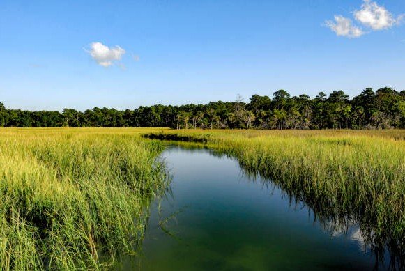
Georgia’s marshes look lush and resilient, stretching across nearly 400,000 acres along the coast. But beneath the surface, scientists say the roots that hold the entire ecosystem together are disappearing at an alarming pace.
University of Georgia researchers warn that salt marsh collapse may begin underground long before communities notice anything above ground.
The Hidden Weakness Beneath a Healthy Landscape
From a boat or a boardwalk, the marsh looks fine. Spartina alterniflora — the dark green grass that defines most of the coastal landscape — has actually expanded in visible cover during the past decade.
Yet, when scientists analyzed the muck beneath the grass, they uncovered something unsettling. Belowground biomass has plunged by almost 75 percent since 2014. This means the roots and rhizomes that anchor the marsh are thinning, weakening, and shrinking.
One small paragraph here: that decline puts more than a quarter of Georgia’s marshland into a vulnerable category.
Researchers took more than 1,100 soil cores from sites stretching from Savannah to St. Marys, working across different seasons and different tidal conditions. The field technicians washed each sample, separated dead strands from living strands, dried them, and weighed them.
That level of sampling had never been attempted in Georgia at this scale.
Years of Labor Reveal Sobering Results
Kyle Runion and Merryl Alber of the University of Georgia said a decade of core sampling changed their understanding of marsh stability. Runion said that aboveground measurements had created a misleading sense of confidence.
One sentence summarizes it: green grass does not guarantee a healthy marsh.
Scientists often judged vitality based on height, density, and chlorophyll, mostly because it was easier and cheaper to measure. But roots stabilize sediment, form peat, support elevation, absorb nutrients, and provide the underground strength that lets a marsh stay intact during sea level rise.
Runion explained that there is almost four times more living material below the surface than above it. Losing that hidden structure weakens the soil, causing it to slump, erode, or sink.
Here is a short table illustrating the contrast between what is visibly measured and what actually drives long-term health:
| Measurement Type | Visible Results | Long-Term Significance |
|---|---|---|
| Aboveground grass cover | Increasing | Misleading indicator |
| Belowground biomass | Declining sharply | Predicts marsh collapse |
One brief note: if belowground loss continues, surface vegetation eventually fails, even when it looks strong years earlier.
Flooding Plays a Central Role in Marsh Decline
Spartina needs regular flooding to exchange nutrients and oxygen. But too much inundation becomes suffocating.
Researchers found that extended waterlogging limits oxygen diffusion in the root zone. This causes plants to invest less energy underground and more above ground, which amplifies structural weakness.
One sentence captures the pattern: the marsh interior often drains more slowly, letting water sit longer and suppress biological health at depth.
Sapelo Island proved to be a striking example. Aerial imagery from 2012 showed a healthy canopy, despite belowground decline that had already begun. By 2024, the same interior pockets had lost their surface vegetation entirely.
That timeline matters. Decline begins beneath the mud before the vegetation above disappears.
Runion’s models indicate that a decade of sea level rise already reduced belowground biomass by roughly eight percent. Another decade could deepen the slope even further.
One short observation: the problem is not immediate, but it is accelerating.
Signs Spread to Other Coastal Regions
Georgia is not alone. Salt marsh loss has been observed as far north as Connecticut and across the Gulf, especially Louisiana. But very few states have long-term belowground data. Managers typically recognize collapse only after the marsh has visibly failed.
One bullet point helps clarify what Georgia’s scientists are offering:
-
Long-term belowground data allow managers to intervene before visible die-offs occur
Researchers from several neighboring states told Alber they intend to begin their own deep sampling programs after seeing Georgia’s results. Some groups hope the satellite model will translate into the Gulf’s complex marsh systems.
One brief comment: the partnership between field sampling and satellite data gives coastal managers a predictive framework instead of a reactive one.
Georgia’s marshes remain one of the most extensive in the country. Yet if belowground decline continues unaddressed, loss could accelerate even if aboveground cover currently looks stable.
Potential Solutions Offer Time, Not Total Rescue
The scientists do not say the entire marsh can be saved. Instead, they argue that coastal managers now have an early-warning system that can identify unstable areas before collapse propagates outward.
That early visibility changes strategy. Instead of waiting for large patches of dead marsh to form, agencies can focus on:
-
Adding sediment to increase elevation
-
Restoring tidal flow to reduce stagnant flooding
-
Securing upland corridors where marshes can migrate inland
Some interventions are already used in restoration projects on the Atlantic Coast. Thin-layer sediment placement, for example, gently raises the marsh surface without harming plant communities.
One sentence here: identifying hot spots increases efficiency and avoids wasting limited restoration dollars.
Marshes are essential for fisheries, storm protection, water quality, and carbon storage. Losing them would have social and economic consequences, especially for coastal communities that face stronger storms.