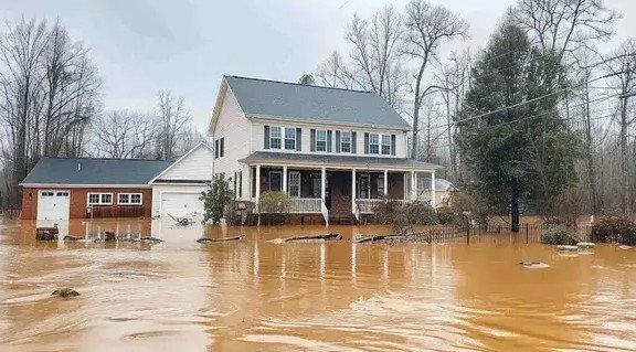
Heavy storms swept through North Georgia on January 10, 2026, bringing intense rains and strong winds that led to widespread flooding. Officials issued a flood warning for the Etowah River in Cherokee County near Canton, which remains active as river levels stay high downstream of Interstate 575.
This weather event caused road closures and safety concerns across the region. Residents in areas like Woodstock and Canton faced dangerous runoff, with emergency teams urging people to avoid travel.
Storm Details and Timeline
The storms started moving into North Georgia early on Saturday, January 10, 2026. A strong front triggered thunderstorms that dumped heavy rain, with some spots getting up to six and a half inches in a short time.
By midday, the National Weather Service put out flash flood warnings for several counties, including Cherokee. These warnings lasted into the afternoon as water levels rose quickly in rivers and streams.
Gusty winds added to the chaos, knocking down trees and power lines in places. The severe weather threat eased by evening, but flooding risks lingered overnight.
Posts on social media showed raging waters and flooded basements, highlighting how fast the situation worsened for locals.

Flooding Impact on Cherokee County
Cherokee County bore the brunt of the flooding, especially around the Etowah River. Emergency managers reported three inches of rain already on the ground by late afternoon on January 10, with more expected.
Roads in Canton and nearby areas turned into rivers, leading to closures and rescues. One resident shared images of basements filled with water, a scene repeated in many homes.
The flood warning for the Etowah River extends until further notice. Experts predict the river could crest above flood stage, threatening properties downstream of I-575.
Local officials worked through the night to monitor levels and clear debris. No major injuries were reported, but the damage to infrastructure is still being assessed.
In comparison to past events, this storm echoes the heavy rains of 2024 in the region, which also caused similar disruptions.
Rainfall Amounts and Affected Areas
Rainfall varied across North Georgia, but some locations saw extreme totals that fueled the floods.
Here is a breakdown of reported rainfall in key spots:
| Location | Rainfall Amount (inches) | Time Period |
|---|---|---|
| Canton | Up to 6.5 | Saturday afternoon |
| Woodstock | Around 3 | Midday Saturday |
| Soque River Area | Over 4 | Throughout the day |
| General North GA | 2 to 5 | Overall event |
These amounts led to flash floods in low-lying zones. Other counties like Forsyth and Hall were under watches earlier, but those have since expired.
The heavy downpour overwhelmed drainage systems, causing backups in urban spots.
Safety Measures and Community Response
Authorities stressed safety during the storms, advising people to stay off roads and seek higher ground. Emergency alerts went out via phone and social media to warn about rising waters.
Community members stepped up, helping neighbors with flooded homes and sharing updates online. One local group organized clean-up efforts as the rain tapered off.
Officials recommend preparing emergency kits with essentials like water, food, and flashlights for future events. They also urge checking local forecasts regularly.
With climate patterns shifting, experts note these intense storms are becoming more common in the Southeast. Recent data from 2025 shows a rise in heavy rain events by about 15 percent in Georgia.
Forecast and Recovery Outlook
As of January 12, 2026, the storms have mostly moved out, but scattered showers could continue through the week. The National Weather Service expects drier conditions by midweek, aiding recovery.
River levels should start dropping soon, but the Etowah warning might last a few more days. Crews are inspecting bridges and roads for damage.
Recovery efforts include assessing property losses and providing aid to affected families. State resources are available for those displaced.
Looking ahead, meteorologists predict a calmer pattern, but they warn of potential winter storms later in January based on current models.
Key tips for residents during recovery:
- Avoid flooded areas to prevent accidents.
- Report damage to local authorities for assistance.
- Monitor updates from trusted weather sources.
This event serves as a reminder of nature’s power and the need for preparedness. Share your experiences in the comments below or on social media to help others stay informed.
