Roads swallowed, rivers rage, and residents scramble in the wake of Chantal’s remnants
The skies opened up over North Carolina and Georgia on Wednesday, turning city streets into rivers and highways into mazes of stranded cars. Hours of torrential rain—fueled by the dying breath of Tropical Storm Chantal—unleashed chaos across both states, with Durham and Atlanta at the epicenter of the unfolding disaster.
By late evening, emergency sirens, viral videos, and flash flood alerts saturated residents’ phones. Officials scrambled to control the damage as rivers surged past historic levels and nearly 100 roads in one North Carolina county alone were rendered impassable.
Durham’s River Nightmare: “It came out of nowhere”
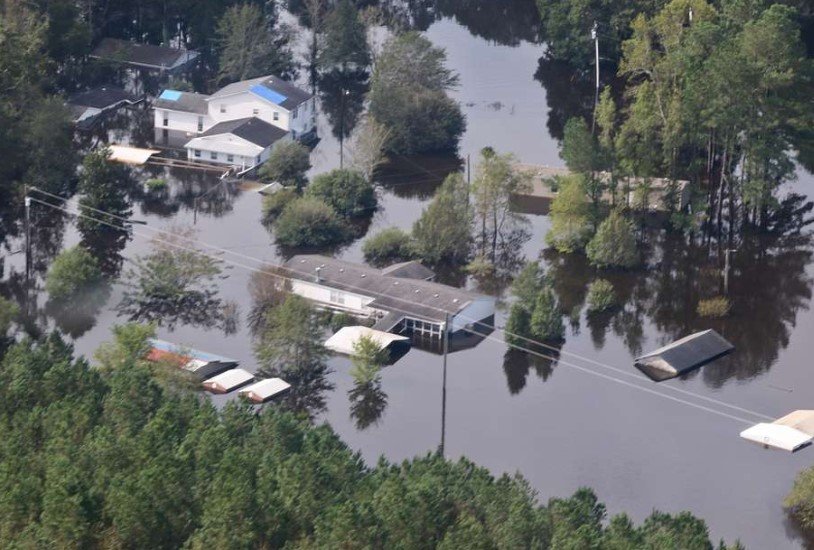
In Durham, it wasn’t just flooding. It was historic.
The Eno River swelled to 25.63 feet, its highest level ever recorded. Nearby, the Haw River surged to 32.5 feet—the second-highest on record. Residents who’ve lived near these rivers for decades said they had never seen anything like this.
“It was like the water was chasing us,” said Tasha Reilly, who barely made it out of her SUV on I-85 before water reached the windows. “One minute it was raining, the next, I was floating.”
Authorities confirmed that more than 100 roads in Chatham County were either submerged or eroded. NC 902, a major connector, collapsed under the pressure of the rushing water.
Atlanta Streets Disappear as Storm Drainage Crumbles
Over in Georgia, particularly across metro Atlanta, the situation wasn’t much better.
Social media filled up with jaw-dropping videos—cars spinning in place like toys, parking lots transformed into lakes, and manhole covers bursting open as sewers failed. One video from the Old Fourth Ward showed floodwater pouring into a MARTA station stairwell like a broken dam.
City engineers say the storm dumped an extraordinary amount of rain in just a few hours. Their preliminary estimates suggest 3 to 5 inches fell in parts of downtown, overwhelming the city’s 100-year-old drainage system.
This one’s a short paragraph.
And just one sentence here too.
The city of Atlanta said its 311 call center received more than 500 emergency requests between 5 p.m. and midnight alone.
Tornado Watches, Warnings Blanket Central NC
As if the flooding weren’t enough, the National Weather Service warned that a possible tornado could form in Durham Wednesday evening.
While no confirmed tornado touchdown had been reported by midnight, Doppler radar indicated rotation and issued alerts for parts of Durham, Orange, and Alamance counties.
One man in Hillsborough said the wind changed direction “in a snap,” and tree limbs started flying. “We threw the kids in the bathtub and hoped for the best,” he said.
-
Flash Flood Warnings were active for:
-
Durham, Chatham, Orange, and Alamance Counties (NC)
-
Northeastern Carroll, Harford, and Baltimore Counties (MD)
-
Metro Atlanta region, including DeKalb and Fulton Counties
-
Authorities advised residents not to drive through flooded roads and to stay home unless absolutely necessary. Dozens of water rescues were reported by 11 p.m.
A Look at the Numbers Behind the Storm
The rainfall from Chantal’s remnants has raised alarms among meteorologists. The storm may have lost its tropical classification, but it’s certainly not done causing trouble.
Let’s break down some key flood statistics reported on July 9:
| Location | Rainfall Amount | River Level (Crested) | Notable Impact |
|---|---|---|---|
| Durham, NC | 8–10 inches | Eno River: 25.63 ft | Record flood; major road closures |
| Haw River (NC) | 6–9 inches | Haw River: 32.5 ft | 2nd highest level on record |
| Chatham County, NC | 7+ inches | N/A | 100+ roads flooded; NC 902 collapse |
| Atlanta, GA | 3–5 inches (avg) | N/A | Drainage overwhelmed, 500+ emergency calls |
The NWS says more rain is expected through Thursday morning, although the worst appears to be over. Still, saturated ground could lead to additional runoff and potential mudslides in higher elevations of North Georgia and western North Carolina.
Locals Share Panic, Frustration—and a Bit of Humor
In the chaos, people found a way to talk about it, to share it, and—somehow—to laugh about it too.
“Only thing missing was an ark,” joked one user on X (formerly Twitter), who posted a photo of downtown Raleigh looking more like Venice than a Southern city. Another clip showed two college kids kayaking through a flooded parking lot at Duke University.
But it wasn’t funny for everyone. A young mother in Apex, NC said her basement flooded while she was trying to get her two toddlers to sleep. “The water was coming in from the back door like it had a grudge,” she said. “We lost the washer, dryer, and probably the furnace too.”
This one’s short.
And this one is even shorter—just a sentence.
Schools in affected counties have announced delays or closures for Thursday. Power outages remain scattered across central North Carolina and metro Atlanta.
What’s Next? More Rain and Long Recovery Ahead
The National Weather Service extended the Flood Watch for central North Carolina through midnight Thursday. While no additional tornado warnings were active as of early Thursday, the agency warned that saturated soil, gusty winds, and ongoing showers could still cause trouble.
The Atlanta Department of Watershed Management said it will begin pumping out major intersections and transit tunnels by morning. But the city also acknowledged that full recovery of storm drains and sewage overflows could take days—or even weeks.
“People are tired, and we know it,” said Durham Mayor Elaine Maddox in a brief late-night press conference. “But we’re going to get through it. We’ve faced hurricanes, we’ve faced ice storms—and we’ll face this together.”
North Carolina’s Department of Transportation said emergency crews would begin inspecting all damaged roads at daylight. Initial repairs on NC 902 could take weeks, depending on how bad the underlying erosion is.
A spokesperson for the National Guard confirmed they had been placed on standby but had not yet been deployed.
Emergency shelters opened in Durham, Chatham, and Alamance counties for displaced families.