A professor’s return to his storm-battered homeland led to new data, local hope, and a unique opportunity for one young researcher from Georgia.
One American Student, One Native Professor, And A Monsoon-Stricken Coastline
January isn’t exactly high season in Cox’s Bazar. Skies hover somewhere between heavy and grey. Roads turn slick and messy. But it was there, among water-logged villages and makeshift shelters clinging to hillsides, that an assistant professor from Georgia Southern University returned home — with a student in tow and a mission on his mind.
Dr. Munshi Rahman wasn’t on vacation.
He was there to trace flood lines, map risks, and bring data-driven hope to a region that’s had more than its fair share of suffering. Alongside him: Emma Robinson, a junior geoscience major eager to get her boots muddy — literally and figuratively — in one of the world’s most climate-vulnerable places.
Their destination? The low-lying, tourist-heavy coastal belt of Cox’s Bazar in southeastern Bangladesh, home to more than 3 million people and, crucially, the longest natural beach on Earth.
It’s beautiful. And during monsoon season, it’s brutal.
Floods, Landslides, And A Long History Of Displacement
The numbers alone are bleak.
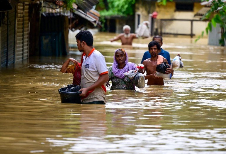
In 2024, more than 7,000 people in Cox’s Bazar lost their homes during violent summer rains and landslides. Three lives were lost. Thousands of shelters — built mostly from bamboo, tarp, and scrap metal — were flattened or washed away.
The problem isn’t new. But according to Rahman, it’s getting worse.
“There’s been so much urban growth without planning. Trees are gone, hills are cut down for shelters, and the landscape is just collapsing in some parts,” he said. “You mix that with stronger weather events each year and it’s basically a perfect storm.”
His solution isn’t flashy: satellite data, GPS tagging, and old-fashioned ground-level surveying. But it works. And it could actually save lives.
What They Found On The Ground — And Why It Matters
Over the course of several weeks, Rahman and Robinson used a blend of tools — including geographic information systems (GIS), drone imagery, and direct community interviews — to create a clearer picture of disaster vulnerability in the area.
A big discovery? Many homes and even entire refugee camps were built directly on unstable slopes.
“We saw camps built right into the hills. One good rain and it’s gone,” Robinson said. “It was shocking. There’s no drainage, no support beams, nothing. Just mud and prayer.”
They weren’t just mapping rocks and ridges, either.
-
Their team noted significant environmental degradation in key districts.
-
Local deforestation made hill slopes especially prone to landslides.
-
Informal housing, common among displaced populations, offered almost zero protection from flooding.
And the risks aren’t just environmental — they’re social too.
A Region Strained By Climate, Migration, And Bad Luck
Cox’s Bazar isn’t just a tourist spot. It’s also where one of the largest refugee populations on the planet — over 900,000 Rohingya people — live in crowded camps, pushed into fragile, often dangerous terrain.
Add climate change to that mix and it’s a slow-moving disaster in the making.
Rahman noted that many development programs still rely on generic, top-level flood maps or decade-old planning models. “That’s not going to help anymore. Conditions on the ground are changing year by year,” he said. “We need street-level data and local insight. That’s what this work is about.”
A Table That Tells the Story
To put their findings in context, Rahman shared this breakdown comparing the structural vulnerability across several surveyed locations:
| Area Surveyed | % Homes on Slopes | Avg. Elevation (m) | Flood Damage (2024) | Primary Construction Material |
|---|---|---|---|---|
| Ukhiya | 78% | 16 | High | Tarp/Bamboo |
| Teknaf | 63% | 22 | Moderate | Corrugated Sheet |
| Kutupalong Camp | 91% | 10 | Very High | Bamboo/Tarpaulin |
| Central Cox’s Bazar | 40% | 7 | Low | Brick/Masonry |
One row. One village. But behind each number, there’s a family sleeping under a leaky roof, waiting for the next storm.
From Data To Action: What Comes Next?
Rahman and Robinson’s work doesn’t end with maps and models.
They’re already handing their findings over to local authorities and NGOs. The hope is that the data can be used to inform better housing placement, early warning systems, and environmental restoration plans.
“This is something we can actually use. It’s not just academic,” one local official reportedly told the research team during a feedback session.
Robinson, still just an undergrad, sees it as the start of something much bigger.
“I didn’t expect to be part of something like this so early in my studies,” she said. “But now I can’t imagine doing anything else.”
And really, how often does a student get to collect data, shape policy, and wade knee-deep through a rice paddy in the same week?