The 2025 Atlantic hurricane season has turned deadly with three powerful Category 5 storms striking the Caribbean and beyond. Hurricane Melissa slammed into Jamaica as a Category 5 monster on October 28, causing massive damage, while earlier storms Erin and Humberto also reached peak strength, marking the most such events since 2005.
This season started late but ramped up fast, fueled by warm ocean waters and climate patterns. Experts warn that rising global temperatures are making these intense hurricanes more common, leading to widespread destruction in vulnerable areas.
Unprecedented Activity in 2025 Season
The Atlantic hurricane season kicked off on June 1, but the first storm did not form until June 23. That slow start gave way to a surge of activity, with Tropical Storm Andrea leading the pack.
By August, Hurricane Erin exploded into the first Category 5 of the year, packing winds up to 160 mph. It skimmed past Cape Verde and the eastern Caribbean, causing deaths and heavy damage without direct landfall.
Hurricane Humberto followed in September, rapidly intensifying to Category 5 status with 160 mph winds. This storm marked a rare back-to-back event, as the season produced multiple top-tier hurricanes in quick succession.
Now, in late October, Hurricane Melissa has stolen the spotlight. It strengthened to Category 5 just before hitting Jamaica, bringing catastrophic winds and rain.
Forecasters note this ties the record for the most Category 5 storms in a single season over the past two decades. Climate scientists link this trend to warmer seas, which provide more energy for storm growth.
Hurricane Melissa’s Devastating Path
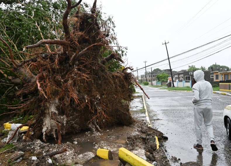
Melissa formed in the Caribbean and quickly gained power, reaching Category 5 with sustained winds over 157 mph. It made historic landfall in Jamaica near New Hope on October 28, the strongest storm to ever hit the island.
Jamaican officials reported severe property damage, with homes destroyed and roads flooded. The slow-moving storm dumped up to three feet of rain in some spots, triggering landslides and widespread flooding.
As Melissa moves toward Cuba, authorities there have evacuated thousands from coastal areas. The storm is expected to bring life-threatening storm surge and heavy rains, potentially weakening slightly but still posing major risks.
Impacts extend to Haiti and the Dominican Republic, where strong winds and waves have already caused disruptions. Recovery efforts in Jamaica are underway, but power outages and blocked access roads complicate aid delivery.
Experts predict Melissa could be remembered like past disasters such as Katrina or Maria for its long-term effects on communities.
Earlier Category 5 Storms This Year
Hurricane Erin set the tone in August as a long-lived Cape Verde storm. It developed from a tropical wave and underwent explosive growth, peaking at 160 mph winds and a pressure of 915 mb.
Though it avoided major landfall, Erin battered Cape Verde with high waves and rain, leading to several fatalities. It also affected the Lesser Antilles and parts of the U.S. East Coast with rough seas.
Next came Hurricane Humberto in September, which jumped from 60 mph to 160 mph in just 48 hours. This rapid intensification caught many off guard, and its small but intense eye brought extreme conditions to nearby waters.
Humberto’s path stayed mostly at sea, but it generated swells that impacted coastal regions. Both Erin and Humberto highlight how quickly storms can escalate in favorable conditions.
These events have strained emergency resources across the region, with relief agencies preparing for more potential hits before the season ends on November 30.
Together, they show a pattern of stronger, faster-developing hurricanes, raising concerns for future seasons.
Historical Context and Comparisons
Category 5 hurricanes are the most intense on the Saffir-Simpson scale, with winds starting at 157 mph. They can level homes, uproot trees, and cause power outages lasting weeks.
The 2025 season matches 2005’s record of four such storms, but this year has three so far: Erin, Humberto, and Melissa. No other season in the last 20 years has seen this many.
For perspective, here is a table of notable Category 5 Atlantic hurricanes in recent years:
| Year | Hurricane Name | Peak Winds (mph) | Major Impacts |
|---|---|---|---|
| 2025 | Erin | 160 | Cape Verde damage, Caribbean swells |
| 2025 | Humberto | 160 | Rapid intensification, ocean swells |
| 2025 | Melissa | 160+ | Jamaica landfall, Cuba threat |
| 2024 | Beryl | 165 | Caribbean islands devastated |
| 2024 | Milton | 180 | Florida flooding and destruction |
| 2019 | Dorian | 185 | Bahamas leveled, long stall |
| 2005 | Katrina | 175 | New Orleans flooding catastrophe |
This table shows how 2025 fits into a trend of increasing intensity. Storms like Dorian stalled over areas, worsening damage, while others like Milton brought record surges.
Preparing for Future Threats
With hurricane season still active until November 30, residents in at-risk areas should stay vigilant. Forecasters predict possible additional storms, though none are forming right now.
Preparation is key to minimizing loss. Communities hit by Melissa are already focusing on rebuilding, but lessons from this season can help everywhere.
Here are some essential safety tips for hurricane-prone regions:
- Stock up on non-perishable food, water, and medications for at least three days.
- Secure your home by boarding windows and clearing loose items from yards.
- Follow evacuation orders promptly and know your local shelter locations.
- Stay informed through official channels like national weather services.
Governments are ramping up response plans, including better early warning systems. Climate action, such as reducing emissions, could help curb future storm strength.
Economic and Human Toll
The financial cost of these storms is staggering. Melissa alone could rack up billions in damages across Jamaica and Cuba, from destroyed infrastructure to lost tourism revenue.
Human impacts are even more profound. Thousands have been displaced, and recovery will take months or years. Mental health support is crucial for survivors facing trauma.
International aid is flowing in, with organizations providing food, water, and medical help. This season underscores the need for resilient building codes and community support networks.
As we track these events, it is clear that proactive measures save lives. Share this article with friends in affected areas, and drop a comment below on how you are preparing for severe weather. Your insights could help others stay safe.